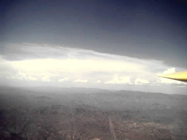
The conditions at the start of my Silver Badge flight.
Soaring has several 'badges' or achievment levels that pilots try to qualify for. They range from the 'just able to solo' A badge up to a 1000 Km badge. The first real cross country soaring badge is the Silver Badge. It requires a duration flight of at least 5 hours, a flight of at least 50 Km (31.1 miles), and a height gain of at least 1000 meters (3281 feet) from an in flight low point.
I started on my silver badge in September of 2000. That day was to be the longest single flight of my life. It was in one of the trainer SGS 2-33 gliders at Turf Soaring School. When I was getting hooked up for the tow, I joked with the person attaching the tow rope. I said "It does not look too much like a 5 hour day.", to which he replied "Well, maybe." The "Long Sit", as it is called, started out just like the other solo training flights which I had made, when I caught a fantastic thermal from 1500 feet above the ground to almost 10000 feet above the ground. With that kind of thermal activity and altitude I had a chance to make the 5 hour mark. I called the ground and asked if there was anyone that could hang around that had witnessed the takeoff and had me in sight for the whole flight. Roy Coulliette, the owner of Turf, said he would and could. With the 5 hour flight safely done, I radioed in that I was coming down after about 5:45 and Roy called back and said "Why don't you fly to make the flight an even six?" Well, why not. I had just enough daylight and touched down at exactly six hours later than my takeoff that day. I came back the next day and did the paperwork to send to the Soaring Society of America (SSA) for verification. Now, just the distance and altitude legs to complete!
In the time since that duration flight, I found and bought the BG 12/16 and had been working on the experimental restricted hours which kept me within 25 miles of the airport. I had done a 'practice' cross country which would have given me the Silver but did not have the equipment or paperwork ready at that time. Tony Smolder, the President of the Arizona Soaring Association (ASA) loaned me his backup electronic recording barograph. I tested it with my GPS, found it to work, then sent it off for calibration. NOW I was ready for an attempt in the old yellow sailplane.
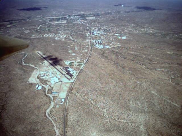
The day finally came on an ASA contest day. I hooked up with Tony to get my pre-takeoff paperwork done and got the flight recorder installed in my glider. I took off toward the Wickenburg airport, some 54 Km upwind. I got off the tow east of Turf in a great thermal. I told the tow pilot to remember this release, because it was for a badge flight. (The tow pilot has to certify where the glider released.) James said that he would, and I was off to what I hoped would be a fun flight. The conditions did not look as good as on my 'practice' cross country flight, but adequate for the task. I soon found it very difficult to get much altitude. There was a shear wind that was blowing the thermals apart and I did not feel comfortable heading up wind. On the flight trace below, this portion of the flight is the big mess of turns just west of Turf.
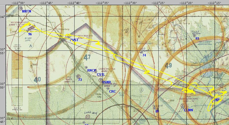
There was a bit of a headwind, as can be seen from the GPS track. The places where I stop to thermal all show a trend to the northeast or downwind. From the picture above, you can see that there were some big storms up to the north of me. There were also some big cumulus stuff down to the south. I had the best looking course. Pretty soon, I broke free from the shear layer and headed out west just about right on the direct course line. I only started deviating off the course line when some promising clouds formed just north, giving me a good marker for the thermals. I knew I had 'final glide' altitude from over the Rio Vista Hills airport to Wickenburg. There were some nice looking clouds on the other side of Wickenburg. Even if I could not reach the thermals under these clouds, I would be able to land at Wickenburg and have my Silver Badge. I arrived over Wickenburg at about 3000 feet above the ground or 5300 feet MSL. Just past the airport I got into a great thermal which took me up to the top altitude of the day, 10300 MSL.
It felt great to climb from 5300 to 10300 in one thermal. At this point I felt that I had 'final glide' back to the home airport about 32 miles away. I could not resist making a couple of turns under a fantastic cloud which took me almost to 10000 feet again. I finished the task over the home airport at 4800 MSL or about 3200 above the ground. I had over 2000 feet to lose before getting into the pattern, so the last thermal turns under that great cloud were not needed, but sure made me feel good.
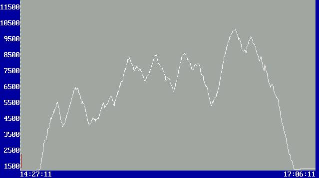
The altitude trace shows my vertical progress along the flight. To make sense of it with the GPS track, the big thermal bunch near the start of the flight is the left most of the three center peaks. It is here at 8500 feet MSL that I decided I had enough altitude to venture forth. The tallest peak over on the right side is the top of the great thermal just west of Wickenburg, where I started home. The trace also shows the thermal that I could not resist just to the right of the big one and some smaller gains that I made while flying straight ahead back to the home field.
The paperwork is all back from the SSA and the flight has been approved! Next is on to the Gold Badge - distance flight of 300 Km (186.4 miles) and a height gain of 3000 meters (9842 feet) - which I hope to complete before the end of the flying season this year.
(POSTSCRIPT: The September 11 attacks on America shut down the flying right at the time that was perfect weather (and my preparation) to try for the Gold Badge. Maybe next year...)
An interesting side note about this flight is that 10 of the 12 ASA contest pilots landed out on this same day. They WERE well south of my flight path, however. STILL, it feels good to make a complete task when others did not.
Created 10 July 2001.
Updated 18 November 2011
Copyright 2001-2011 by Paul R. Jorgenson